
DOC 06AUTONOMY DEVELOPMENT
Mapping and navigation
Alongside vehicle simulation, LEVIATHAN includes hydrographic processing from raw soundings to a charted surface, an analytic navigation filter, and the marine navigation calculations an operator uses to plan and steer. Vehicle state estimation on canonical sensors is described on Localization.
Hydrographic survey pipeline
| Component | What it does | Scope |
|---|---|---|
| Motion correction and patch test | Turns a travel time along a beam into a georeferenced sounding, using vehicle attitude, transducer lever arms and sensor timing. Includes patch-test estimation of mounting biases | Models the systematic errors that do not average out, for example a roll bias that shifts outer beams on every ping |
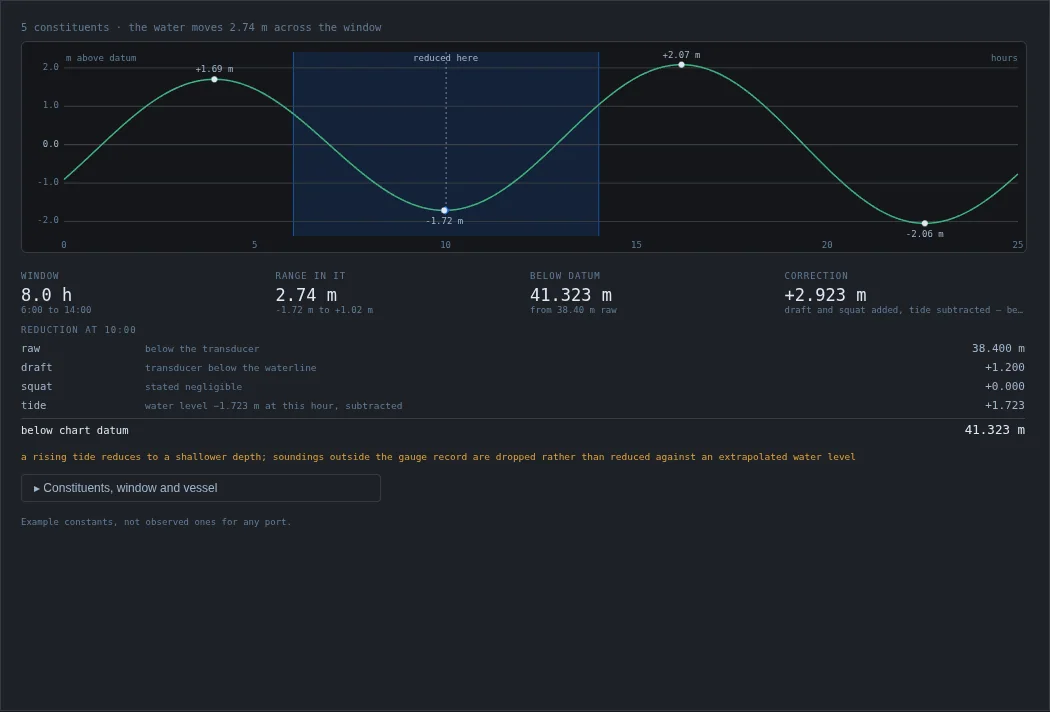
| Tide and dynamic draft | Harmonic tide synthesis from constituents, or an observed series; static draft plus speed-dependent squat; reduction of soundings to chart datum | Soundings outside the tide record are dropped rather than reduced against an extrapolated level |
| CUBE-class gridding | Keeps competing depth hypotheses per grid node, as in Calder and Mayer's CUBE (2003). It chooses at the end and reports how close the decision was, instead of averaging two real surfaces into a depth that is wrong for both | CUBE-class: the structure of CUBE, not a certified implementation |
| IHO survey orders | Total vertical uncertainty allowed at a depth for each IHO survey order | Reference values |
| Kongsberg .all reader | Walks a .all file datagram by datagram, verifying framing and checksums, and counts what it contains | Container framing only; per-datagram field layouts are not decoded |
| Bathymetry import | Loads regular grids from ASCII x y z, CSV or GeoTIFF as a simulation seabed (Import bathymetry panel) | Complete, regularly spaced grids only |
| Charts | Georeferenced chart view with base-map, shaded-relief, sea-mark and isobath layers, coverage plots and soundings (Chart, Coverage chart, Soundings panels) | Map tiles come from online providers and need a network connection; their attribution is displayed |
Analytic navigation filter and estimation tools
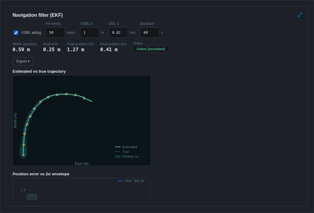
LEVIATHAN has two estimators. The canonical error-state filter on Localization works on the canonical World and can drive control. The navigation EKF described here is the older analytic-tier filter behind the Dashboard's Nav filter panel. It fuses the simulated sensor suite into a single estimate of where the vehicle is, as an AUV's navigation system does. Its 12-state vector is NED position, ZYX attitude, body velocity and body rates, the same convention the dynamics use. Prediction is kinematic, with a random-walk velocity model. Updates are loosely coupled and applied as each sensor reports: DVL velocity, IMU rates, USBL position fixes, surface GPS, depth and compass heading. Between fixes the estimate dead-reckons and its covariance grows; a fix pulls it back.
| Tool | Description | Character |
|---|---|---|
| Nav filter | 12-state loosely coupled INS / DVL / USBL / GPS / depth / compass EKF, compared with truth | Analytic |
| Cooperative localisation | Range-only localisation of several vehicles from acoustic ranges | Analytic |
| System ID | Identification of vehicle parameters from simulated motion | Analytic |
| SLAM eval | Absolute and relative trajectory error of estimates on a synthetic range-measurement benchmark | Evaluation only |
- The analytic navigation filter runs with the analytic sensors. Its estimate is evaluated against truth and is not fed back into a controller. Estimate-driven control is available on the canonical World through Localization.
- LEVIATHAN does not include a SLAM system, an online occupancy or TSDF mapper, or a sonar mosaicking pipeline.
Mapping status
LEVIATHAN does not build a map estimate from its own state estimate and sensors. The pieces that touch mapping today are these:
| Component | What it is |
|---|---|
| Hydrographic gridding | Charted surfaces from soundings with known positions (above); a survey product, not an online map |
| Local visual landmark map | Keyframes and landmarks inside the perception library's visual odometry; camera-only and local, not connected to localization (Perception) |
| SLAM evaluation | Trajectory-error metrics and a range-factor back-end on synthetic benchmarks (SLAM eval), and RGB-D registration on rendered depth; evaluation tools, not a mapping system |
| Cooperative localisation | Range-only factor graph across a fleet, on the analytic tier |
| World bathymetry | Seabed grids and terrain as simulation truth, not as an estimate |
Navigation computations
| Calculation | Description |
|---|---|
| Rhumb lines and routes | Constant-heading tracks, distances and routes, alongside geodesics |
| Set and drift, course to steer | The current's effect from intended versus achieved track, and the inverse: what to steer so the water carries you to your destination |
| Endurance | Range and time available for a given energy and speed |
| Behaviour arbitration | Multi-objective helm in the MOOS-IvP interval-programming style. Each behaviour scores the whole decision space and the helm chooses the best weighted compromise, with closest-point-of-approach calculations |
| COLREGs classification | Encounter geometry for Rules 13–17 (overtaking, head-on, crossing) with the role and required action for each vessel. The classification is reciprocal: two vessels never both conclude they are the stand-on vessel |
| Acoustic propagation | Ray fans, eigenrays, transmission loss and sonar-equation detection range through a sound-speed profile |
| Survey coverage and missions | Lawnmower survey patterns with swath coverage metrics; mission estimates of distance, time and energy (Survey coverage, Mission panels) |
These are planning and decision aids that compute answers for given inputs. Route planning around obstacles is not part of the application.